Soil erosion on sloping land in China is mainly prominent in the loess soil on the Loess Plateau, the red loam soil in the upper Yangtze River hills, the purple soil in the Chuanzhong hills, and the black soil in the Northeast Plain. Among them, Loess Plateau is the most serious and concentrated area of soil erosion on sloping farmland in China. Severe soil erosion has caused thousands of hills and ravines, bare hills and bald mountains, and frequent disasters on the Loess Plateau, which seriously restricts the social, economic and cultural development of the whole Loess Plateau.
In this article, we take the Loess Plateau as an example to illustrate the environmental impact of soil erosion on sloping land in China at both macro and micro levels. On the macro level, we analyze whether the dominant factor of soil erosion on the Loess Plateau is natural erosion or man-made erosion from the perspective of overall environmental evolution and climatic factors; on the micro-level, we focus on the possible environmental hazards caused by soil erosion on the Loess Plateau.
To anticipate the future environmental conditions, we must first understand the history of environmental evolution, and understanding the laws of environmental evolution from history is the main way for human beings to adapt to future environmental changes and ensure the sustainable development of human society. To understand the impact of soil erosion on the Loess Plateau, we need to clarify whether soil erosion on the Loess Plateau is mainly natural or anthropogenic erosion. Natural erosion refers to soil erosion that occurs in the natural environment without human influence, and its occurrence depends on the changes of natural environmental factors, such as geological tectonic movements, earthquakes, glaciers, biological and climate changes, etc.; while anthropogenic erosion is soil erosion caused by human activities, such as engineering construction as well as indiscriminate logging and unreasonable farming.
From the geological structure, the loess plateau ground broken, valleys, valley slopes steep, very favorable to water erosion, the history of many earthquakes and crustal movement is intensified the degree of slope fragmentation and undulation; from the climate conditions, the loess plateau is located in semi-arid semi-humid climate zone, uneven distribution of precipitation season, mainly concentrated in the summer, more heavy rainfall; from the soil characteristics, loess soil loose, no stratification In terms of soil characteristics, loess soil is loose, unstratified, mainly powdered, with high calcium carbonate content, and easily disintegrated by water. All these are the natural causes of soil erosion on the Loess Plateau.
I think the leading factor of soil erosion on the Loess Plateau is the natural cause. The main reasons are as follows: First, for the cause of loess, the more popular are wind and water, both of which believe that loess is not soil-borne; that is, loess may also be mobile, and the loess plateau is not a balanced and stable state, and soil erosion in the loess area is a process of its own environment tending to the equilibrium state. Secondly, the soil erosion and the sediment of the Loess Plateau originated in the geological period, without the destruction of natural vegetation by humans, and the soil erosion was already developing in the original natural vegetation environment; the fourth or fifth level branch ditches of the Yellow River have formed thousands or tens of thousands of years ago (i.e., before human started frequent activities); thirdly, the human factor is mainly through engineering construction, indiscriminate logging, and unreasonable farming, etc. Third, human activities mainly affect the change of vegetation cover on the ground through engineering construction, deforestation, and unreasonable farming, thus intensifying soil erosion and environmental degradation. Many studies in the literature analyzing the dominant drivers of vegetation cover change on the Loess Plateau show that precipitation is the main factor affecting vegetation cover change on the Loess Plateau.
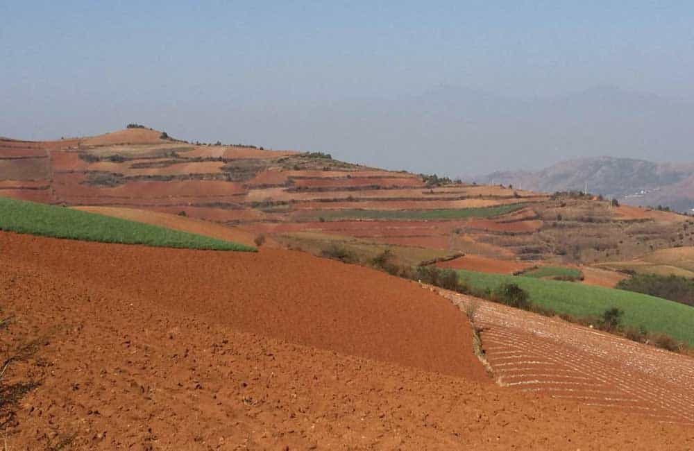
There are about 2.64 million hm2 of dryland in China, accounting for 53.8% of the cultivated land, almost all of which is sloping. With the expansion of population, the sloping arable land is opening up more and more steeply, and soil erosion is increasing. According to estimation, under the same rainfall intensity, the erosion amount of 25° slope arable land is more than ten times or even dozens of times of the erosion amount of 5° slope arable land. Soil erosion on sloping land is seriously endangering the economic, social, and ecological security and development of China.
Due to the concentration of erosive precipitation on the Loess Plateau, the slope is easy to run water and soil and the soil itself has low erosion resistance, which makes the erosion of the slope arable land with fine furrows occur frequently. After a large number of research results, according to the hydraulic erosion mechanism, it is pointed out that the erosion and transport capacity of fine channel water flow is much larger than the erosion and transport capacity of raindrop strike and slope sheet water flow. The field investigation and test results of Loess Plateau prove that, when the slope surface has fine ditch development, the slope surface erosion sand production will increase several times to dozens of times. This is due to the plowing of the sloping land, in the soil often have larger pores, local will form obvious sink, easy to gather water flow, water flows down to form shallow caves, when the water flow out of the surface of the fine ditch will begin to develop at the exit, and soon form a fine ditch erosion, the flow of sand content will be significantly increased.
The nutrients of sloping land soil contain a large amount of nitrogen, phosphorus, potassium, medium content of calcium, magnesium, and trace elements such as manganese, iron, copper, zinc and aluminum, among which there are ionic state fast-acting nutrients and inorganic or organic fast-acting nutrients transformed by decomposition. Soil nutrients in sloping land are mainly lost in two ways: first, soluble nutrients dissolved in runoff are lost with runoff; second, nutrients adsorbed and bound to the surface of soil particles in the inorganic state, and organic matter are lost with the sediment washed by runoff.
Due to soil erosion, the sloping land becomes a “three running fields” of running water, running soil and running fertilizer, and the number of bacteria, actinomycetes and fungi tend to decrease significantly with the increase of soil erosion over the years of reclamation. The number of bacteria, actinomycetes and fungi in the topsoil layer of a 20-year-old farm was significantly reduced. The number of bacteria, actinomycetes and fungi in the topsoil layer decreased by 79%, 67% and 83%, respectively. The activities of sucrase, alkaline phosphatase, and protease decreased by 75%, 73%, and 65%, respectively, in the agricultural land reclaimed for 30 years compared to the forest soil. As a result, the land became increasingly infertile, the physical and chemical properties of the soil deteriorated, and the permeability and water-holding capacity of the soil decreased, which intensified the development of drought and made agricultural production low and unstable. Bai Hongying et al. studied soil erosion and loss of organic matter, total nitrogen and effective phosphorus on slopes using artificial rainfall experiments, and the results showed that nutrients increased with slope and rain intensity, and nutrient loss was positively judged with soil loss.
No-till and minimum-till methods can greatly reduce the loss of soil erosion and correspondingly reduce the loss of nitrogen and phosphorus. It was found that no-till can greatly reduce the rate of soil erosion and the loss of nutrients N and P. China implemented the policy of returning farmland to forest and grass at the end of the last century. According to the following plan developed by the relevant provinces and districts in the Loess Plateau soil erosion area. Although the return of cropland to forest and grass may bring a temporary decrease in grain production, the positive impact of ecological following is seen. At the same time, technological progress, the construction of agricultural infrastructure and the improvement of the ecological environment are bound to promote and boost food production.
Rural surface source pollution refers to agricultural production activities dissolved or solid pollutants, such as soil particles in farmland, nitrogen, phosphorus, pesticides heavy metals, rural livestock manure and household waste and other organic or inorganic substances, from non-specific geographical areas, under the action of precipitation and runoff erosion, through the farmland surface runoff, farm drainage and underground seepage, so that a large number of pollutants into the pollution caused by rivers and lakes. Soil erosion of sloping farmland makes sediment transport has adsorption capacity for each relevant heavy metal element along the way, which is carried into the water bodies of rivers and lakes. And the sediment produced with the loss of organic pollutants such as nitrogen, phosphorus and chemical pesticides, causing eutrophication of reservoirs, lakes and other water bodies, seriously threatening the water conservancy facilities and their benefits.
The dominant factor of soil erosion on the Loess Plateau is natural, and human activities only intensify the degree of soil erosion. Modern tectonic movements caused the uplifting of large areas in the Loess Plateau area, which is the main internal force and geological background of soil erosion in the Loess Plateau. The instability of climate (periodic changes of cold, warm, dry and wet) and the resulting changes in vegetation growth and decline are the external forces of erosion and sand production. At the same time, the middle reaches of the Yellow River are the main birthplace of Chinese civilization, and human activities have been long and intense, which have caused the most serious damage to the pristine natural environment, artificially accelerating soil erosion on the Loess Plateau and making soil erosion in the region develop in a more intense direction. The main environmental hazards caused by soil erosion on the Loess Plateau are sand production by erosion on sloping land, loss of soil resources, formation of “above-ground rivers” in the lower reaches of the Yellow River; nutrient loss from sloping land, decrease in soil quality and land degradation; agricultural surface pollution, etc.